Development of a Python-based Algorithm for Enhanced Digital Terrain Model Extraction
A novel approach to preserving dune geomorphology and maintaining ground point accuracy
Abstract
This research presents a novel Python-based algorithm for extracting high-quality Digital Terrain Models (DTMs) from UAV-derived photogrammetric point clouds in coastal environments. The algorithm addresses critical limitations in commercial software packages by employing a sophisticated workflow that preserves subtle geomorphological features while accurately representing ground surfaces in complex coastal landscapes.
Key Findings
- The custom algorithm demonstrated remarkable improvements over Pix4D's automated terrain extraction, reducing mean vertical difference from -1.228m to -0.001m
- Standard deviation improved from 1.933m to 0.028m, indicating superior consistency in terrain representation
- The custom DTM showed a reduced range of error (2.513m versus 27.782m), representing a 25.269m improvement
- The algorithm effectively preserves microtopographic features critical for coastal monitoring and management
Methodology
Algorithm Overview
The methodology presents an automated workflow for generating high-resolution Digital Terrain Models (DTMs) from point cloud data in complex environments. The process consists of three main phases: preliminary processing, classification, and terrain synthesis.
Processing Phases
Phase 1: Preliminary Processing
The workflow begins with initial point cloud preparation, including non-ground object removal and sample data collection. This phase involves manual preprocessing to remove buildings, vehicles, and water bodies that could interfere with terrain modelling.
Phase 2: Classification
The classification phase employs a confidence-based multi-pass classification system to categorize points into distinct classes (mud, sand, tree, shrub). This uses a Random Forest machine learning approach to classify points based on various features.
Phase 3: Terrain Synthesis
The terrain synthesis phase involves sophisticated ground point extraction, obstruction removal, and surface reconstruction techniques. This follows a three-stage workflow to generate a clean ground surface.
Key Results
Accuracy Comparison
The comparative analysis between the custom DTM algorithm and Pix4D's automated terrain extraction revealed substantial improvements in both accuracy and reliability of terrain representation. The custom algorithm's accuracy metrics showed significant improvements across all measures.
| Metric | Pix4D DTM | Custom DTM | Improvement (m) |
|---|---|---|---|
| RMSE (m) | 2.290 | 0.028 | 2.262 |
| Mean Difference (m) | -1.228 | -0.001 | 1.227 |
| Median Difference (m) | -0.451 | 0.000 | 0.451 |
| Standard Deviation (m) | 1.933 | 0.028 | 1.905 |
| Range (m) | 27.782 | 2.513 | 25.269 |
Table 1: Comparative analysis of the Custom DTM versus Pix4D-Generated DTM against ground points
Visual Comparison
Beyond the statistical improvements, visual comparison revealed significant qualitative differences between the custom DTM and Pix4D's output. The custom algorithm maintained plausible elevation levels in interpolated areas, better preserving the natural topography of the coastal environment.
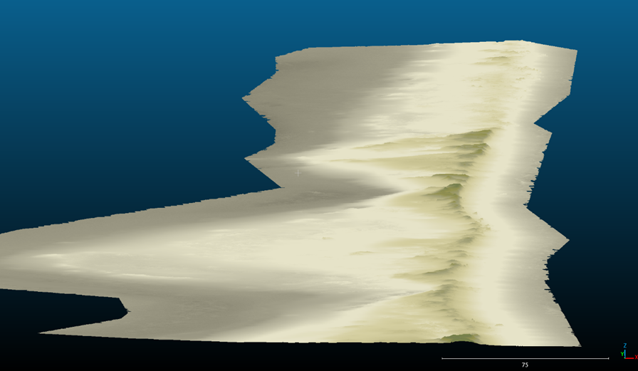
Figure 2: Custom-generated digital terrain model with enhanced gap filling interpolation.
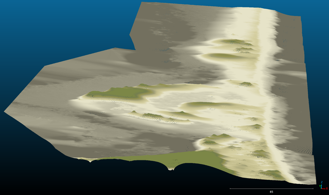
Figure 3: PIX 4D generated digital terrain model showing exagerated terrain features.
Error Distribution
Analysis of error distribution revealed that Pix4D's DTM exhibited significant artifacts including artificial terrain undulations, erroneous elevation spikes, and misrepresented flat surfaces. In contrast, the custom algorithm maintained terrain fidelity across varied surface types, with errors primarily concentrated at the edges of vegetation patches.
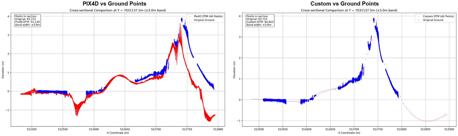
Figure 4: Cross-sectional comparison at Y = 7031137.5m showing significant deviations between PIX4D DTM (left) and ground points, while the custom DTM (right) closely follows the actual terrain profile
Discussion
The comparative analysis between the custom DTM algorithm and Pix4D's automated terrain extraction revealed substantial improvements in both accuracy and reliability of terrain representation. The results demonstrate that targeted algorithmic approaches can significantly outperform generic commercial solutions, particularly in maintaining terrain fidelity while processing complex environmental features.
Key Strengths of the Custom Algorithm
A key strength of the custom algorithm lies in its preservation of genuine ground point characteristics. Rather than applying aggressive terrain modifications, the approach focused on intelligent point classification and outlier removal, particularly for mud, sand, and low vegetation points.
The high accuracy of the custom algorithm can be attributed to its preservation of original ground point values, with minimal manipulation of the data. The small displacement range observed primarily resulted from the surface fusion process using mean tessellation and outlier removal, rather than from any direct modification of ground point values.
Void Interpolation Accuracy
What the statistical analysis does not fully capture is the accuracy of each DTM's void interpolation. Examining Pix4D's DTM reveals significant artifacts in void areas, suggesting that the algorithm might employ a global implicit surface reconstruction approach without proper consideration of terrain characteristics. This results in unrealistic terrain representation in areas with data gaps.
In contrast to Pix4D's exaggerated topography in canopy voids, the custom DTM maintains plausible elevation levels in interpolated areas, better preserving the natural topography of the coastal environment. This qualitative observation is crucial for accurate photogrammetric terrain modelling in coastal monitoring applications.
Operational Considerations
Despite its superior performance, the custom algorithm does present certain operational challenges. Unlike Pix4D's one-click solution, it requires user understanding of the underlying scripts and processes. This increased complexity demands greater technical expertise and time investment. However, this limitation is offset by the significantly improved accuracy and reliability of the results, particularly crucial for scientific and engineering applications.
Conclusion
The development and validation of the custom DTM extraction algorithm addressed a critical limitation in commercial photogrammetric software. The custom approach demonstrated remarkable improvements over Pix4D's automated terrain extraction, reducing mean vertical difference from -1.228m to -0.001m and median deviation from -0.451m to 0.000m. This represents a transformative advancement in terrain modelling accuracy for coastal environments.
The results strongly suggest that Pix4D's automated DTM generation should not be relied upon for engineering or environmental management applications where accurate terrain representation is critical. The magnitude of errors observed in Pix4D's output (27.782m range) could lead to significant misinterpretation of terrain characteristics and potentially flawed decision-making in coastal management contexts.
The custom algorithm's superior performance, while requiring more user involvement, provides a much more reliable foundation for terrain analysis and coastal monitoring applications. Its ability to maintain accuracy while processing complex environmental features makes it particularly valuable for coastal applications where subtle terrain variations can have consequential implications for environmental assessment and management decisions.
Future development of the algorithm should focus on:
- Adaptive terrain response capabilities to handle varying environmental conditions
- Increased robustness in point classification
- Faster processing options for specialized applications
- Further automation of the workflow while maintaining accuracy
Related Research
Interested in Elevation Models?
Contact our team to discuss this research or explore how our DTM extraction algorithms can benefit your geospatial projects.
Discuss This Research